Hiking Trips
Our trails this year are intended to offer something for everyone, with the widest range of abilities and interests possible. The Appalachian Trail is right next door to us in Radford, providing difficult all-day trails that climb to the top of peaks. There are also paved ADA-accessible greenway hikes along the banks of local waterways, trails that wander past streams and waterfalls, and through the dramatic ridges and valleys of the Allegheny Mountains that stretch south to north – and everything in between. The land is marked by substantial geologic variation, including sedimentary shale, limestone, sandstone, and igneous basalt. The Central Appalachian Forest ecoregion is traversed by the largest drainage divide in the East, between rivers of the Atlantic Slope and Mississippi Valley. Hiking in this region will provide experiences you will remember for many years.
With no exceptions, we practice safe hiking and follow the good stewardship of leaving no trace.
Hiking Difficulty Ratings
Please read the descriptions of difficulty levels carefully before signing up for a hiking trip. We are not all the same. Especially in hiking, the choice of an appropriate level of difficulty that matches your abilities and suits your need for comfort versus your need for a challenge is important. Besides the overall difficulty rating, we have tried to provide some objective measures of distances and elevation gains in each hike description.
Gentle: Someone in fair hiking condition. Slight elevation change.
Moderate: Someone in good hiking condition. Increased mileage; moderate elevation gain.
Strenuous: Someone in very good hiking condition. Increased mileage; significant elevation changes.
Very Strenuous: Someone in excellent hiking condition. Significant increases in mileage and elevation gain.
Extremely Strenuous: Someone in exceptional hiking condition. Trails are not always available. Significant increase in mileage and extreme elevation gain. Technical aspects of a hike for very experienced hikers.
Required Equipment and Guidelines for Hiking Trips
Required on all trips:
- A desire for fun, adventure, and self-discovery.
- Canteens or water bottles: at least one quart of water for ½-day trips and at least two quarts for full-day trips.
- Proper, secure, supportive footwear is absolutely, positively necessary. No bare feet. No open-toed shoes of any kind (flip-flops, open-toe Tevas, etc.) unless on a paved pathway and/or medically necessary.
- Cell phones are for emergency use only. Respectfully, we request that all cell phones be turned off while traveling and on the trail. We desire that all trip participants interact with nature and each other. Taking photographs is encouraged.
Required on some trips:
- Trips involving wading, slogging, or swimming require sturdy, secure, slip-resistant footwear to protect against sharp rocks, glass, etc. (see Shoe Requirements),
- Evening trips require flashlights.
- It is strongly suggested that you bring:
- Rain jacket or poncho. You never know when you will need it.
- Sunscreen.
- Snacks if you are planning to expend a lot of energy.
- Insect repellent.
- A dry bag for all water stomp-type trips if you have anything you do not want to get soaked.
- Swimsuit and towel for the water hikes (and a change of clothes for the van ride back to campus).
- 611: Mill CreekLimit 13
 A beautiful trek! The total hike is about three miles out from the parking lot and back. We will follow the trail makers from the reservoir to the Waterfall Trail. We'll navigate over rock outcrops, and the trail becomes very narrow in spots as we go up the gorge. At one point, before the falls, we’ll also cross a branch that meanders down to the creek on a wooden single bridge. We think it's a work of art.
 - 621: Stiles Falls (Family Friendly)Limit 13
 Stiles Falls is a 45-foot waterfall located on the property of Camp Alta Mons. The hike begins with an easy walk to the trailhead, then changes to steep inclines, several creek crossings, and rock hopping up to the falls and water pool. There are large boulders around the falls and a water pool where you can sit and relax, or you can scramble over to swim or play around in the shady pool of water at the falls. We’ll provide lunch and plenty of time to enjoy one of the area’s favorite destinations. You must have proper footwear, at least a quart of water per person, and a pack to help carry lunch. Wear a swimsuit under your clothes if you would like to get in the water. Hiking Distance: 3.2 miles round-trip, with 300 feet of total climb. Drive time: 35 minutes.
 - 622: Triple SlogLimit 13
 This hike is so enjoyable that some SUUSI-goers do it every year! We hike a short distance down the road to get to a point where we can enter the forest above the Cascades waterfall, bushwhack down to Little Stoney Creek, and take off into the wild. We hike in the stream and swim/wade through pools, climb around trees and rocks, and climb and play in three waterfalls. You will get wet (completely soaked if you like). Due to the climbing and scrambling on wet, slippery rocks, this is one of our most challenging hikes. Secure, slip-resistant, immersible footwear required. Wear a swimsuit/nylon shorts and bring a towel and/or dry clothes for the ride back. Backpacks and contents are likely to get soaked in the fun! Hiking distance: about three miles, with wet rock scrambling. Drive time: 60 minutes.
 - 624: Sunset on Bald KnobLimit 13
 The trail starts at the historic Mountain Lake Hotel. A steep, half-mile climb up a fern-bordered trail brings us to the 4361-foot high knob. It's the highest point in the area, with extensive views in several directions and some interesting cliffs and rock formations. We'll pause to enjoy this beautiful time of day at the top of the mountain as we wait for the sun to set. The descent is easier following a jeep road, but will be after sunset. A flashlight is required. This is a moderate hike for adults, especially after the first half mile. Hiking distance: 1.6 miles round-trip, with 500 feet of total climb. Drive time: 50 minutes.
 - 631: Nature Conservancy Service ProjectLimit 13
 We will be helping The Nature Conservancy(TNC) by cleaning and repairing trails in the Falls Ridge area. There are approximately 5 miles of trails in this area, giving participants an opportunity for hands-on work while learning about the work being done by TNC to preserve various parcels of land in their natural state and help maintain, and in some instances save, various species native to a particular area. This is a wonderful opportunity for SUUSI folks to give back to the community and enjoy some camaraderie midweek during SUUSI. Lunch is provided. The Falls Ridge preserve is close to Radford!
 - 632: McAfee KnobLimit 13
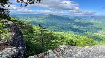
With its stunning, 270-degree panoramic views of the surrounding valley and mountains and signature ledge that has become a popular place for photos, McAfee Knob should be included in any trip that includes hiking in Virginia's Blue Ridge. It's been recognized by USA Today Travel as one of the most spectacular hikes in the United States! The knob is located atop Catawba Mountain with an elevation of 3,197 feet and is one of the highlights of the Appalachian Trail. This hike is out and back. We will follow a white blazed trail for approximately four miles to the overlook. Coming back, we will be on a fire road, which is a nice leisurely descent back to the trailhead. Bring a pack to carry your lunch.
- 633: Cascades Falls (Family Friendly)Limit 13
 We'll hike along Little Stoney Creek to the spectacular 66-foot Cascades Falls and the cold swimming hole at the bottom. The hike is a climb up a groomed, but rocky trail and is easier and smoother on the descent. Wear a swimsuit underneath your clothes and bring secure, slip-resistant, immersible footwear for getting in the water (required). A second trip is also offered on Friday - trip #652. Hiking Distance: 3.7 miles, with 700 feet of total climb. Drive time: 50 minutes.
 - 634: Connelly's Run (Accessible, Family Friendly)Limit 14
 Connelly's Run is a stream that flows from a historic spring down to the New River through a wooded canyon with varying microclimates, all within Radford's Wildwood Park. Stroll or roll as you are able along the 6-foot wide, fully-paved streamside shared-use trail. We will enter from a small parking lot above the spring and hike in and back. A group with varying physical abilities can enjoy a nature hike together; steep side-trails are not part of our route, but remain within sight in case your group includes some high-energy young ones. There are smooth bridge crossings, benches, picnic tables, and natural/historical signage. SUUSI provides vans, but they are not ADA-compliant; personal vehicles will be required for transport. Accessible restroom facilities are available midway, at the trailside. Hiking Distance: 1.5 miles round-trip, fully paved, with only a slight grade. Drive time: 10 minutes.
 - 641: A Day At Mountain LakeLimit 14
 Spend a day at Mountain Lake — yes, this is the location of the iconic movie, Dirty Dancing! There will be several options for how you might fill your time, and you can decide on the spot. Enjoy exploring the now-dry lake riverbed, hike the two-mile perimeter of the lake, visit the shops, take in some birding, check out the historic lodge, and sit in a rocking chair enjoying the mountain views … or any combination of all that there is to offer. We will bring a picnic lunch, and there are restaurants and bars onsite in case you’ve got a hankering for something different. Sunscreen, bug spray are recommended; comfortable shoes and water are required. Drive time: 45 minutes
 - 642: Dismal Falls (Family Friendly)Limit 14
 A long-time favorite for enjoying a beautiful area with minimal effort. A good nature experience for families with young children due to the short distance. We drive over Cloyd's Mountain through scenic, pastoral countryside to a popular recreation area. We'll hike a mostly flat section of the Appalachian Trail to a scenic 10-12 foot stairstep falls with a cold basin or pool for swimming. We climb over some slippery rocks to get into the water. There will be time for walking or playing around the creek bed or just sunning on the rocks. Bring the kids and enjoy the afternoon watching them discover the great outdoors! Hiking distance six miles. Drive time: 45 minutes.
 - 651: Dragon's ToothLimit 13
 Dragon's Tooth is one of Virginia's iconic hiking destinations, part of the "Triple Crown," and is well-known and popular. Our out-and-back route starts on the Dragon's Tooth Trail, moving steadily upward, and with stream crossings on rocks and becomes more challenging after we join the Appalachian Trail. The last half-mile has rock scrambles, even metal rungs to climb, as we approach the prominent 360º view from the end of Cove Mountain at 3,025 feet. We will stop for lunch near the sharply pointed sandstone cliffs that jut up like dragon's teeth. The return is nearly pure descent. Watch your footing in wet weather. You will carry a provided lunch, and be sure to bring 2 liters of water, as there can be plenty of exposure to the sun at the top. Hiking Distance: 4.6 miles round-trip, with 1,250 feet of total climb. Drive time: 50 minutes.
 - 652: Last CascadesLimit 13
 Our Friday afternoon trip to Cascades Falls should be a pleasant close to the week, and has been a perennial favorite for some. We'll hike along Little Stoney Creek to the spectacular 60-foot Cascades waterfall and the cold swimming hole at the bottom. The hike is a climb up a groomed, but rocky trail and is easier and smoother on the descent. Wear a swimsuit underneath your clothes and bring secure, slip-resistant, immersible footwear for getting in the water (required). The pace will be slightly faster than the family-friendly version of this trip offered on Wednesday - trip #633. Parents: this trip overlaps with the Youth's closing circle Friday afternoon. Hiking Distance: 3.7 miles, with 700 feet of total climb. Drive time: 50 minutes.